Land Use & Transportation
The Appalachian Mountains historically have been a barrier between the major population centers of the East Coast and the Midwest. Parallel to the East Coast and spanning from southern Canada to Alabama, relatively few major interstate highways cross this mountainous region and few major urban areas located within due in large part to the topography of the area.
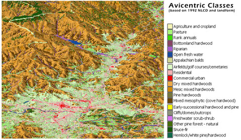
Situated on a plateau in the midst of mountain ranges and located at the confluence of the French Broad and Swannanoa Rivers, Asheville is located at a strategic point where major transportation routes cross. The topographic character of the City is composed of wide and often abrupt variations due to cuts created by ravines leading from higher elevations to the rivers. Suitable land for development in the Asheville Metropolitan Area becomes increasingly scarce as urban growth encroaches upon the limited supply that now exists. While the Asheville Plateau has allowed for the development of human settlement in this area, there are inherent access problems associated with this location. As such, the majority of transportation routes, and land uses associated with those routes, have remained largely the same throughout most of Asheville’s history.
Situated on a plateau in the midst of mountain ranges and located at the confluence of the French Broad and Swannanoa Rivers, Asheville is located at a strategic point where major transportation routes cross. The topographic character of the City is composed of wide and often abrupt variations due to cuts created by ravines leading from higher elevations to the rivers. Suitable land for development in the Asheville Metropolitan Area becomes increasingly scarce as urban growth encroaches upon the limited supply that now exists. While the Asheville Plateau has allowed for the development of human settlement in this area, there are inherent access problems associated with this location. As such, the majority of transportation routes, and land uses associated with those routes, have remained largely the same throughout most of Asheville’s history.
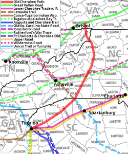
Animal trails crisscrossed the Western North Carolina region long before the arrival of humans, and the same large game animals that created the trails attracted Native American hunters. Early trails tended to follow the lines of least resistance. These trails played a major role in allowing early European exploration of the region and access for colonial trade and settlement. These settlers, who later followed the paths with wagons, often broadened the way, slowly transforming these trails into the first roads of the territory and, later, routes of railroads and state highways. Asheville scarcely claimed a spot on the map until the 1820’s with the creation of the Buncombe Turnpike, a link in the Dixie Highway, which connected the region with Tennessee, Georgia, and South Carolina until the Civil War. Purchasing the land previously used for the Buncombe Turnpike, the railroad's arrival in Asheville in 1880 marked another milestone in the city's transportation history. In present-day Asheville, I-26 intersects I-40, which are both major interstate highways connecting the Midwest with the Southeast and the East Coast with the West Coast, respectively. These two interstate highways have become primary shaping forces on the City of Asheville, Buncombe County, and the surrounding areas.
The distribution and location of land uses in Asheville have been heavily influenced by the transportation system. Originally a bit tenuous, with development dependent upon natural features as well as accessibility, this linkage has become more intertwined in the past 50 years. Development of all types closely follows the location of roads as evidenced by the pattern of Asheville’s development during the past 30 years. The transportation system also provides the framework for the development of the community. Land uses needing easy access locate along streets that can provide the level of access required to assure the success of the land use. Residential development in Asheville has occurred over the years in proximity to commercial service and employment areas and within access to major roads. Commercial development has occurred along major traffic corridors. Industrial development in the City has long been situated on relatively flat land beside the rivers, rail service and major roadways. Recreational needs have been addressed through the establishment of parks located in major residential areas.
Downtown Asheville and surrounding neighborhoods that developed before the dominance of the automobile are dense and have an interconnected street system. Uses are mixed and easily accessible with streets and sidewalks providing a range of transportation options. The greatest mixture of uses is found in Downtown Asheville, where everything from offices to retail outlets to residential uses can be found. Downtown has and continues to serve as the heart of the City, providing goods and services to residents and visitors. The roadways that intersect in Downtown Asheville and radiate out from it provide connections to the rest of the City, providing lifelines for the flow of people into and out of Downtown.
The population centers within Buncombe County continue to be located within the long-standing and more densely developed areas of Asheville. Rural areas, though developed during the housing boom, still do not represent larger population clusters. This is likely due to both the prevalence of second home and retirement home/land purchases that occurred during the boom, as well as the larger-lot development that occurs in more rural areas.
Though growth has slowed due to the economic downturn, it remains clear that development continues to be concentrated in lower-lying areas in closer proximity to transportation corridors. Other factors which influence the development of the City include the close proximity of two incorporated areas (the Town of Woodfin and Biltmore Forest), Pisgah National Forest, and the Blue Ridge Parkway.
Though growth has slowed due to the economic downturn, it remains clear that development continues to be concentrated in lower-lying areas in closer proximity to transportation corridors. Other factors which influence the development of the City include the close proximity of two incorporated areas (the Town of Woodfin and Biltmore Forest), Pisgah National Forest, and the Blue Ridge Parkway.
